First real heat of the summer — and it may hang around
Heat builds across most of California starting Thursday, and this one could run about a week. Here's what we're seeing, why a long event is a different animal from a short one, and what it means for fire weather.
Hello all — weather and fire update.
The first real heatwave of the summer will be marching in toward the end of this week for most of California, arriving Thursday. If the models are correct, this could be a long-duration event on the order of seven days. Let's hope they're wrong.
Communities away from the immediate coast will feel it most, and we'd expect heat advisories fairly widely, with excessive heat warnings possible in the interior valleys and foothills once it builds. The coast keeps some marine relief. Everywhere inland, plan on heat.
Why a long one is different
The number everyone watches is the afternoon high, but in an event like this the more useful number is the overnight low. Under a deep ridge, nights stop cooling off. Buildings never fully shed the heat they took on the day before, so air conditioning starts each morning a little further behind than it did the morning before — even with no change in the daytime high.
People work the same way. Heat is cumulative, and for older adults it tends to bite on days four through seven rather than day one, after several nights of poor sleep and slow dehydration have stacked up. That's the part of a seven-day event that catches people out: the first couple of days feel manageable and suggest the rest will be too.
If you only track one thing through the week, we'd suggest overnight lows at each site. When those stop dropping into the 60s and start holding in the mid-70s, that's your signal the event has moved into its harder phase.
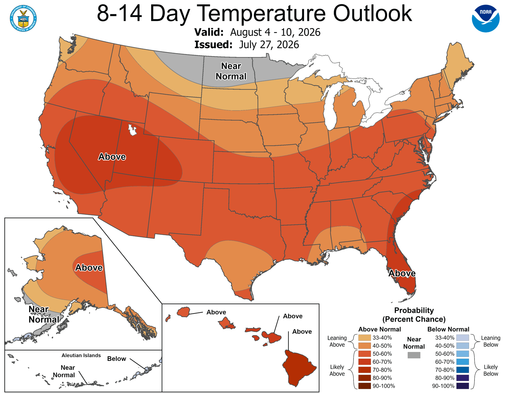
Worth reading it for what it is: a probability of running above normal, not a forecast of a specific temperature. But when the back half of a long event is already leaning this hard in one direction, it's a reason to plan for the full seven days rather than hope for relief around day four.
Fire weather
Fire weather will increase through the period. Not so much wind — this is a plume-dominated setup, where heat and dryness run deep enough that a fire can create its own weather instead of being pushed around by the ambient one.
In practice that means a fire can build a tall column, pull hard indrafts from any direction, and then throw downdrafts and spot fires outward when that column collapses. A wind-driven fire tells you roughly where it's going. A plume-dominated fire doesn't, which is why warning times in this kind of pattern can be shorter than people expect.
For most sites, though, the likelier impact isn't fire at all — it's smoke. A smoky stretch is its own event for a resident population with heart and lung conditions, and it can arrive from a fire a long way off.
One more thing: the grid
Statewide heat means statewide peak load, so Flex Alerts are likely and rotating outages aren't out of the question in the back half. Public Safety Power Shutoffs are wind-driven and less likely in this particular pattern, but a site can lose power for plenty of ordinary reasons on a week like this. Worth knowing where you stand on backup before Thursday rather than after.
Now is the time to prepare for ultra heat. Anything that needs a vendor — an HVAC service call, a generator repair, rental cooling — is easy this week and hard by Friday, once every operator in the state is calling the same short list of people.
Any questions, just ask. Stay cool out there.